StädteRegion
Breadcrumb
Roetgen
Of course Roetgen is not the only place, through which one can get to the Eifel. For the German-Belgian nature park Eifel/Hohes Venn, as well as the still very young national park Eifel it, however, is a very important access point.
The municipality Roetgen with its roughly 8500 inhabitants consists of the villages Roetgen, Rott and Mulartshütte. The village is located on the northern slope of the Hohe Venn in 420 to 500 meters height, surrounded by one of the largest inter-connected area of woodland in North-Rhine Westphalia.
In 1475 the name „roettgen“ for the first time also appeared in a document for a settlement of 80 morgen meadows and farmland, inhabited by Dam Deusterts, who had to pay his duties to the earl of Jülich. He was obviously not the first resident in Roetgen, as the document also mentions that the settlement some time ago had been in desolated condition.
During the course of the following century more and more land was cleared. As the ground was wet and not very fertile, each farmer needed land around his farm. As a result a scattered settlement came into existence, the diameter of which today is about 4 kilometres. During the last few decades the building density has, however, strongly increased, today agriculture is no longer of importance.
For the village Rott, as its name indicates, also a settlement on cleared woodland, the names of the residents liable to payment are listed in a forestry commissioner’s and chamberlain’s statement of account of 1503/1504.
Mulartshütte was first mentioned in 1430 with the privilege of operating an iron mill.
Who today reaches „Münsterbildchen“ via the „Himmelsleiter“ (ladder to the sky), part of the B258, gets a first view of Roetgen, can, however, hardly see more, at least in summer, than the towers of the two churches and higher buildings rising from the green. Around all the three parts of the village large deciduous and coniferous forests are stretching out, which invite for long and relaxing walks and hiking tours. Especially attractive in the nature reserve Struffelt between Roetgen and Rot, through which also the Eifelsteig passes, which meanwhile every day attracts many hikers. In the further course of the Eifelsteig the Hohe Venn is reached and eventually the Steling, with 658 meters the highest elevation of the Monschau region.
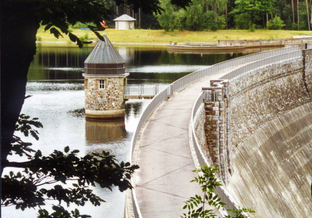
The one who walks down from the Struffelt to Roetgen will soon see the Dreilägerbach reservoir with its 32 meters high and 240 meters long dam wall. It was built in 1909 – 1911 and has a capacity of 4.3 million cubic meters. A valuable property of the water used as drinking water and commercially used water is its low degree of hardness. The high water quality is achieved by means of a filtration plant, which is among the most modern in Europe.
Besides the city of Aachen and other places of the new city region, also the Dutch villages Vaals and Kerkrade are provided with its water.
Like a gate is used to enter a place, it can also be used for leaving it. A stay in Roetgen offers many possibilities to do so. To the South the attractions are the Eifelsteig with Monschau, the Rursee, the national park Eifel, Blankenheim and the river Ahr, also Trier and the river Mosel are within the range of a day trip. To the North the picturesque small town of Kornelimünster, starting point of the Eifelsteig, as well as the old imperial city of Aachen are on the way.
Kontakt
Gemeinde Roetgen
Hauptstraße
55
52159
Roetgen
Tel: +49 2471 18-0
Fax: +49 2471 18-89
info@roetgen.de


Social Media


